
ACR ResQLink View RLS
4.8Editor score
Return Link confirmation
Five-year battery life
Global satellite compatibility
Compare the best locator beacon for hiking the PCT, including PLBs and satellite communicators for navigation, messaging, tracking, and emergency SOS features.
A locator beacon for hiking the PCT can provide a critical communication link when cellular coverage disappears across California, Oregon, and Washington. The right device should alert rescuers, share your location, and remain dependable through variable terrain, severe weather, long stretches of isolation, and demanding battery conditions.
This guide compares ten personal locator beacons and satellite communicators based on emergency coverage, positioning, messaging, mapping, durability, battery life, and practical trail features. It includes dedicated 406 MHz PLBs, subscription-based satellite communicators, phone-connected devices, and complete accessory bundles.
Each review explains the strongest reasons to consider a particular model, along with registration, subscription, and compatibility limitations. The badges identify three standout choices, while the comparison table offers a quick overview. Product availability and pricing can change, so confirm current details before purchasing.
4.8Editor score

4.6Editor score

4.6Editor score
This side-by-side comparison highlights the central differences among dedicated PLBs, subscription-based satellite communicators, renewed equipment, and smartphone-assisted emergency devices. It also shows how each product approaches registration, SOS activation, navigation, messaging, and battery performance.


The ACR ResQLink View PLB425 combines a dedicated 406 MHz personal locator beacon with a bright LED strobe, an infrared strobe, and a compact, buoyant housing. Its 4.6 rating reflects a strong balance of emergency-focused features and ease of carrying. For a PCT hiker who wants a dependable rescue link without managing a communications subscription, it is especially compelling.
We may earn a commission when you buy through this link, at no additional cost to you.
Once activated, the beacon sends an SOS distress signal directly to Search and Rescue services worldwide. The alert includes a GPS position, while the 121.5 MHz homing signal helps rescuers locate the signal more precisely. The device relies on the COSPAS-SARSAT satellite system, allowing the distress message to reach appropriate rescue agencies without a personal monitoring center.
The supplied information also describes non-emergency self-tests and GPS tests through text or email when the optional 406Link testing subscription is used. That is a useful diagnostic option, although it means the beacon itself remains usable for emergencies without a subscription. Its limitation is practical rather than fundamental: this is primarily an SOS device, not a general-purpose satellite messenger for route updates, weather requests, or family check-ins.
The included clips, straps, lanyard, and oral inflation tube clip make it easy to attach to a pack, belt, or clothing. Buoyancy is especially useful for PCT water crossings and for anyone who might fall into a reservoir, river, or lake. This is our best overall choice for hikers who value simple activation, broad satellite compatibility, and freedom from ongoing service plans.
The strongest advantage is direct 406 MHz distress transmission through international rescue satellites. Because no subscription is required for emergency use, the device can remain in a pack for years without becoming another recurring expense to maintain.
The combination of LED and infrared strobes helps rescuers detect the hiker in daylight, darkness, and low-visibility conditions. The buoyant enclosure also adds protection around PCT waterways where gear can be accidentally submerged.
We may earn a commission when you buy through this link, at no additional cost to you.
The ACR ResQLink View RLS is the most highly rated product in this guide, with a 4.8 rating. Its defining feature is Return Link Service, which confirms that Search and Rescue has received the distress signal. That confirmation can reduce uncertainty during an emergency and makes this a strong premium option for PCT hikers who value additional confidence beyond sending an alert.
We may earn a commission when you buy through this link, at no additional cost to you.
The RLS supports GPS, Galileo GNSS, and MEOSAR compatibility, providing a broad foundation for global positioning and rescue communication. It also carries a five-year battery life and more than 28 hours of operational life. A digital display and infrared strobe improve visibility and device readability, while built-in buoyancy and a multifunction clip system support use in varied outdoor conditions.
As with a traditional PLB, its day-to-day communication functions are limited. The supplied data does not describe a general satellite messaging service, weather forecasts, live tracking, or turn-by-turn navigation. It is therefore best viewed as a focused emergency beacon rather than an all-purpose trail communicator. Hikers who want regular family check-ins may prefer one of the subscription-based alternatives.
The RLS is well suited to backpackers, section hikers, and travelers who carry a PLB specifically as a last-resort safety system. Its Return Link confirmation, long maintenance interval, and broad satellite compatibility justify consideration as the premium dedicated-beacon choice, while the absence of a subscription keeps ownership relatively simple.
Return Link Service gives the user feedback that the emergency distress signal has been received by Search and Rescue. This closes an important information gap and makes the beacon especially reassuring for solo or remote itineraries.
A five-year battery life reduces the need for frequent replacement checks. More than 28 hours of operational life provides additional endurance for emergencies involving delayed access, poor weather, or difficult terrain.
We may earn a commission when you buy through this link, at no additional cost to you.
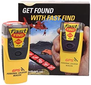
The McMurdo FastFind 220 is a straightforward personal locator beacon built around simple deployment, antenna extension, anti-tamper seal removal, and activation of the ON button. Its 4.5 rating reflects a focused product designed for harsh, remote environments, making it a sensible dedicated safety device for much of the PCT.
We may earn a commission when you buy through this link, at no additional cost to you.
This listing is programmed for the US country code. The device can function internationally, but the initial emergency point of contact will be the US Search and Rescue authorities with which the PLB is registered. For PCT hikes passing through California, Oregon, and Washington, that US programming is a relevant consideration rather than a hidden complication.
Registration is required by law in most countries and should be completed before the hike. Emergency responders use the associated information to identify the owner and learn about travel plans. An outdated registration can slow the response process, so the hiker must maintain a current emergency contact and provide a meaningful trip plan.
The FastFind 220 best suits hikers who want a conventional PLB without a subscription or a complicated user interface. It lacks the regular messaging and tracking features found in satellite communicators, but that narrow purpose makes it dependable and easy to understand. It should only be used in grave and imminent danger because false alerts divert rescue resources.
The three-step activation process reduces the number of decisions required in a stressful emergency. A hiker can deploy the antenna, remove the anti-tamper seal, and press the ON button without navigating a touchscreen.
A properly completed registration links the beacon to the owner and emergency contacts. It also allows rescue teams to receive current travel information, making registration maintenance as important as charging the device.
We may earn a commission when you buy through this link, at no additional cost to you.
The Garmin inReach Mini 2 combines a dedicated satellite communicator with features that are genuinely useful throughout a PCT trip. It supports two-way messaging, interactive SOS, location sharing, and TracBack navigation, giving it more day-to-day value than a conventional PLB. Its 4.6 rating makes it one of the strongest all-around choices in the guide.
We may earn a commission when you buy through this link, at no additional cost to you.
An active satellite subscription is required for communications and emergency functions, and some jurisdictions regulate or prohibit satellite communication devices. Once activated, the device can send text messages and emails, share a MapShare location, and provide interactive global SOS support. TracBack routing helps a hiker return to the starting point along the route already traveled.
The Mini 2 also includes a digital compass, Garmin Explore synchronization, and support for waypoints, courses, activities, and collections. It can pair with compatible Garmin wearables and handhelds. These features make it more versatile than a basic beacon and suitable for hikers who regularly communicate with family, travel partners, or an emergency coordination service.
Battery life reaches up to 14 days in 10-minute tracking mode, which is meaningful for an extended traverse. The principal trade-off is the ongoing subscription and the need to keep it charged. For a hiker who wants more than emergency activation, however, this is a balanced and practical way to combine communications, tracking, and navigation.
The Mini 2 can replace several separate trail tools by combining satellite messaging, check-ins, location sharing, emergency activation, and basic route recovery. It is especially useful for PCT hikers who want family contact without waiting for a genuine emergency.
TracBack can guide a lost hiker toward the starting point of a recorded journey. Synchronization with Garmin Explore adds waypoints, courses, activities, and topographical mapping, making the device useful for both planning and field use.
We may earn a commission when you buy through this link, at no additional cost to you.
The ZOLEO Satellite Communicator offers a phone-centered approach to satellite safety. It uses a paired smartphone to transmit texts and emails over the Iridium network, cellular service, or Wi-Fi, choosing the lowest-cost available connection. With a 4.4 rating, it appeals to hikers who want familiar phone-based communication without needing a large dedicated device.
We may earn a commission when you buy through this link, at no additional cost to you.
For emergencies, ZOLEO can send an SOS alert with a GPS location to a 24/7 monitoring center. It also offers Medical Assist for non-emergency help and unlimited check-ins through the device or app. Users receive a dedicated SMS number and email address, while regular messages can include GPS coordinates. Regular waypoint sharing is identified as an optional add-on.
Its IP68 rating supports outdoor durability, and the stated battery life exceeds 200 hours. Weather forecasts, long messages, and device sharing add convenience. The central trade-off is dependence on a compatible smartphone and an active service plan. A damaged or dead phone could therefore limit access to some functions, and the device does not provide the same physical simplicity as a dedicated PLB.
ZOLEO is a good fit for PCT hikers who regularly depend on their phones and want a compact way to extend messaging beyond cellular coverage. It is less suited to someone who prefers a standalone physical beacon or wants emergency SOS without any subscription-related commitment.
ZOLEO sends messages through a paired smartphone, allowing the hiker to use a familiar interface. It selects the available lowest-cost network among satellite, cellular, and Wi-Fi connections, which can make routine check-ins more convenient.
A battery life of more than 200 hours provides ample margin for a long hike. It is a meaningful advantage when the device is used for repeated check-ins rather than being kept solely as an emergency reserve.
We may earn a commission when you buy through this link, at no additional cost to you.
The Ocean Signal rescueME PLB1 is built for hikers who want a small, dedicated emergency beacon that can be activated with one hand. At only 4 ounces, it takes up very little pack space, yet it carries a 4.6 rating and a robust set of rescue-oriented features. That makes it particularly attractive for fast hikers and travelers who minimize carried gear.
We may earn a commission when you buy through this link, at no additional cost to you.
The beacon includes a 66-channel GPS receiver and a 1-candela high-intensity strobe. It is waterproof to 49 feet, more than 24 hours of operational life, and a seven-year battery. A dedicated mounting clip attaches easily to a life jacket or backpack, and the one-handed design is intended to remain usable even under difficult conditions.
It communicates through international government rescue satellites and requires no subscription. Like other PLBs, it is meant exclusively for grave and imminent danger; false alerts can endanger lives and disrupt Search and Rescue operations. There is no indication that it supports two-way messaging, live tracking, weather forecasts, or route navigation, so it should be treated as a safety backup rather than a communications center.
The PLB1 is a strong recommendation for PCT hikers who need one dependable emergency tool and value compactness, long battery life, and straightforward activation. It is less appropriate for those who want to send route updates or maintain contact with family throughout the hike.
The PLB1 weighs just 4 ounces and takes up minimal room in a backpack. Its mounting clip makes it easy to keep on a life jacket or externally accessible section of gear without adding noticeable weight.
Waterproofing to 49 feet and a seven-year battery support readiness across long seasons. More than 24 hours of operating life adds endurance for emergencies where rescue access is delayed.
We may earn a commission when you buy through this link, at no additional cost to you.
This Garmin inReach Mini 2 Flame Red bundle combines the communicator with a USB cable, charging adapters, a vehicle adapter, a microfiber cleaning cloth, and a portable battery charger. The 4.6-rated core device remains the focus, but the bundled power accessories make it attractive to hikers who want a more complete field kit.
We may earn a commission when you buy through this link, at no additional cost to you.
The communicator supports interactive SOS through the Garmin Response coordination center, along with two-way text messages, email, social media posting, and communication from one inReach device to another. It offers TracBack routing, MapShare location sharing, a digital compass, detailed weather updates, and global Iridium satellite coverage. Flexible subscription options support different usage patterns.
Measuring 4 by 2 inches and weighing 3.5 ounces, the device is compact and built to MIL-STD-810 standards with IPX7 water resistance. Battery life is stated at up to 14 days in the default 10-minute tracking interval and up to 30 days at a 30-minute interval. These figures make it realistic for long-distance travel, although actual results depend on use and conditions.
The bundle is best for a hiker who wants charging flexibility, particularly one traveling by vehicle or using power banks. If a separate charger and portable battery are already owned, the standard inReach Mini 2 may be the more streamlined choice. Either way, an active satellite subscription remains necessary for the relevant services.
The included portable battery charger and multiple adapters provide several ways to replenish the device away from household power. This is useful during long PCT sections and at trailheads where a vehicle or camp power source may be available.
Interactive SOS, two-way messages, email, weather, TracBack, and MapShare make this more than a basic emergency transmitter. Garmin device compatibility also allows it to work with compatible handhelds and wearables.
We may earn a commission when you buy through this link, at no additional cost to you.
The renewed Garmin inReach Mini provides access to the familiar inReach satellite communication platform at a smaller 4.2 rating than the newer models. It supports two-way text messaging through the global Iridium network, interactive SOS to a 24/7 search and rescue monitoring center, and messaging through compatible Garmin devices.
We may earn a commission when you buy through this link, at no additional cost to you.
The free Garmin Earthmate app adds downloadable maps, U.S. NOAA charts, and color aerial imagery when paired with a compatible device. Optional weather forecast services are available in basic and premium packages. This combination of communication, mapping, and rescue activation makes the renewed unit more versatile than a pure emergency beacon.
The main concern is the renewed designation. Buyers cannot assume that the device has the same appearance, battery condition, or warranty experience as a new unit. The 4.2 rating may reflect differences in condition or satisfaction, so purchase documentation and the seller's return terms deserve careful review. A satellite subscription is still required.
This model makes sense for a value-conscious hiker who understands and accepts the risks of renewed electronics. It is less appealing when maximum warranty support or the newest hardware is important. For the PCT, its compact communications and mapping functions remain useful, provided the device is thoroughly checked before the trailhead.
Two-way messaging, interactive SOS, and Garmin device support provide a broad communication feature set. It is a practical option for hikers who want more contact options than a dedicated PLB offers.
Before relying on a renewed unit, check its physical condition, controls, charging performance, and activation process. A careful pre-trip test is especially important for a device intended to provide an emergency link in remote terrain.
We may earn a commission when you buy through this link, at no additional cost to you.
The Motorola Defy Satellite Link is a lightweight, phone-dependent communicator designed to extend check-ins and emergency alerts beyond ordinary cellular coverage. It supports two-way satellite-enabled messaging, works with iOS 14 and later or Android 10 and later, and has a straightforward check-in function for sharing coordinates or a message.
We may earn a commission when you buy through this link, at no additional cost to you.
Its SOS assist can trigger an emergency request without a conventional cellular connection. The supplied information states that unlimited SOS is included with service plans. For routine contact, a user can send coordinates or a brief message to family through satellite coverage, making the device approachable for hikers already comfortable with mobile apps.
The 3.7 rating is the lowest among the ten products, so buyers should not treat it as a direct equal to feature-rich satellite communicators. The service plan is required, and the connected phone remains an important part of the experience. The product information does not describe offline maps, detailed weather services, TracBack navigation, live tracking, or Garmin-style device pairing.
Motorola Defy Satellite Link is most appropriate for a hiker seeking a simple way to send check-ins and access SOS assistance without a large dedicated device. It is less suitable for users who need advanced navigation, extensive mapping, standalone emergency activation, or a broad collection of trail communication features.
A single check-in action can send coordinates or a message through satellite service. This direct approach is useful for hikers whose primary communication need is a concise status update rather than detailed mapping.
Compatibility with recent iOS and Android systems broadens device choice, but the phone remains central to operation. Prospective buyers should verify current app, account, and service requirements before relying on it as their only emergency communicator.
We may earn a commission when you buy through this link, at no additional cost to you.
The ACR Bivy Stick combines two-way satellite communications, live tracking, offline mapping, weather, and emergency monitoring in a device designed for travelers and outdoor teams. Its 3.8 rating places it behind several higher-rated alternatives, but the feature set is especially relevant to PCT hikers who travel with companions or want family to follow their route.
We may earn a commission when you buy through this link, at no additional cost to you.
Users can send unlimited customizable GPS check-ins and share a live map with coordinates and a breadcrumb trail. GroupTrack allows messaging and location sharing with up to 12 people, while the device can be managed through the Bivy app, a mobile device, or a web browser. Dedicated phone and email addresses are assigned after activation, making off-grid contact straightforward.
The built-in GPS supports offline navigation, and the app provides global offline maps, location, pace, mileage, and altitude information. A collection of more than 50,000 curated adventures is also described. The Bivy Stick uses global Iridium coverage and offers 24/7 emergency monitoring through Global Rescue, with alerts activated through the device button or app.
A subscription is required, and a dedicated monthly or annual airtime option must be selected. The main trade-off is that the lower 3.8 rating suggests some buyer dissatisfaction despite a generous feature list. Bivy Stick is still a compelling option for PCT hikers who prioritize group tracking, offline maps, and active communication over a minimal emergency-only design.
Live tracking can display the hiker's coordinates and breadcrumb trail, allowing contacts to follow progress. This adds useful context beyond a single check-in and is helpful when a journey changes unexpectedly.
GroupTrack supports location sharing and messaging for up to 12 people. Trail teams, guides, and families can therefore coordinate through one system, although each user still needs compatible app and service access.
We may earn a commission when you buy through this link, at no additional cost to you.
The best locator beacon for hiking the PCT depends on whether priority is a subscription-free emergency alert, two-way communication, navigation, or group tracking. Consider the device type, satellite system, registration process, endurance, and expected use before making a selection.
A personal locator beacon is designed primarily for one-button emergency activation and typically does not require a subscription for SOS. It is an excellent safety-only option, but routine check-ins and family updates are outside its core function. A satellite communicator adds messaging, location sharing, weather, and often navigation or tracking, usually in exchange for an active service plan. PCT hikers should decide whether they want emergency reserve or an all-purpose communication tool.
Choose a PLB for simplicity and independence from service plans. Choose a communicator when regular contact, route details, or weather information are important.
PLBs generally must be registered with the appropriate national authority because registration connects the distress signal to the owner and emergency contacts. The McMurdo FastFind 220 in this guide is programmed for the US, while the ACR devices use international satellite systems. Make sure the registration process is available for the country where the device will be carried and update contact information before every major trip.
Current registration is part of emergency preparation, not an administrative afterthought. An outdated record can delay the handoff from an alert to a meaningful search operation.
Dedicated PLBs commonly use the international 406 MHz distress system, while communicators often use Iridium or another satellite network. The supplied products also mention COSPAS-SARSAT, MEOSAR, Galileo, and GPS compatibility. These systems provide global coverage, but availability, reception, and the response pathway can differ by device. Look for a clear explanation of where alerts go and how the device confirms receipt.
A Return Link function can offer direct reassurance that Search and Rescue has received a signal. Interactive monitoring provides another useful layer but normally depends on a service subscription.
Battery claims are most meaningful when tied to operating mode. Garmin specifies up to 14 days for the Mini 2 at a 10-minute tracking interval and up to 30 days at 30 minutes. The ACR PLBs advertise multi-year storage readiness and more than 24 or 28 hours of emergency operation. Frequent tracking consumes more energy than occasional SOS-only use, so match the intended mode to the length of the hike.
For a PCT hiker, one or two weeks of normal tracking is often more relevant than a headline maximum. Carry a charging option for trips exceeding the stated interval.
The PCT crosses rain, snow, dust, mud, streams, and steep terrain. Water resistance, physical shock resistance, and reliable controls matter even when a hiker expects careful gear handling. The rescueME PLB1 is waterproof to 49 feet, the Mini 2 is IPX7 rated, ZOLEO carries IP68 protection, and the Garmin Mini 2 bundle is described as MIL-STD-810 compliant.
A durable enclosure is not the same as a waterproof guarantee under every condition. Keep ports covered, inspect seals, and use a protective case without blocking the activation controls.
GPS positioning is standard across emergency systems, but navigation depth varies. The Garmin Mini 2 adds TracBack, a digital compass, and synchronization with Garmin Explore. ZOLEO supports weather forecasts and location sharing, while Bivy Stick includes offline maps and navigational data. Dedicated PLBs such as the rescueME PLB1 and McMurdo FastFind 220 focus on rescue positioning rather than route guidance.
Do not mistake a coordinate display or emergency beacon for a full navigation system. Hikers who navigate technical trail junctions should carry a dedicated map, compass, and navigation skill alongside the device.
ZOLEO, Motorola Defy Satellite Link, and parts of the Garmin experience depend on a compatible smartphone or app. Phone-based operation can be intuitive and may reduce the number of devices carried, but a damaged, flat, or frozen phone can limit communication features. A standalone PLB provides a more independent way to transmit an emergency alert, while a dedicated communicator offers a physical interface and built-in GPS.
Choose phone-based tools for convenience and choose standalone equipment for independence. Whichever type is selected, test the complete setup before departing.
The rescueME PLB1 weighs 4 ounces, and the Garmin Mini 2 weighs 3.5 ounces. Larger dedicated PLBs may add more bulk but can provide larger controls, displays, or strobes. Consider where the device will live: a belt clip, life-jacket mount, pack pocket, or accessible pocket. Emergency tools should remain reachable without unpacking the entire load.
Choose the smallest device you are comfortable operating and likely to carry every day. A feature-rich unit left at home because it is too bulky provides no protection on the trail.
Begin by registering a PLB or activating the service for a satellite communicator before leaving home. Confirm that your emergency contacts, home country, and relevant travel information are correct. Download required maps, create waypoints, and synchronize the device with its companion app while reliable cellular and Wi-Fi service is still available.
Carry the beacon in an accessible location and keep the device protected from impact without obstructing its controls. Review the activation sequence, test-message procedure, and charging method before the hike. On the trail, use scheduled check-ins and tracking modes appropriate for the expected duration. Save battery by reducing tracking frequency when extended coverage is not needed.
After the trip, inspect the device for moisture, dirt, antenna damage, and connector wear. Clean it according to the manufacturer's instructions, recharge it fully, and confirm that the battery indicator is healthy. Keep registration or service details current, and do not activate SOS or coordinate test functions unless the instructions specifically permit that use. False alerts can divert rescue resources and create real danger for other people.
A locator beacon is not legally required for most ordinary PCT hikes, but it can be valuable where cellular coverage is unreliable. A dedicated PLB provides subscription-free emergency signaling, while a satellite communicator adds check-ins, messages, weather, and tracking. The right choice depends on your risk tolerance, party size, experience, and the importance of regular off-grid communication.
A PLB is simpler and generally better for emergency-only use because it sends a distress alert without requiring a subscription. A satellite communicator is better for trail updates, family contact, live tracking, weather, and sometimes offline navigation. Some hikers carry a compact PLB as a backup to a primary satellite communicator, although that adds weight and cost.
Yes. The products in this guide are designed to communicate through satellite networks rather than ordinary cellular towers. Their exact satellite systems differ, but all are intended to operate in remote areas where a phone has no conventional signal. Emergency use, service-plan rules, and regional legal restrictions still apply.
Register the device with the authority responsible for the country where it will primarily be used, then verify that the information matches your real emergency contacts and travel plans. Registration is required by law in most countries. Revisit the record before each major trip, especially if you change your route, phone number, or emergency contact.
A modern phone can be invaluable on the PCT when coverage exists and may run many navigation, mapping, and weather apps. It can also fail through damage, battery exhaustion, cold, or software problems. Carrying a dedicated beacon adds redundancy, while a phone-based satellite product offers convenience but still depends partly on the paired phone and service.
Choose a schedule that reflects your route, party, weather, and the expectations of your contacts. Daily check-ins are common, but longer stretches may need additional waypoint sharing. Use tracking intervals that balance location updates with battery life, and tell contacts what to do if they miss a scheduled update.
Choose a mode that provides the location and communication frequency needed for the trip without exhausting the battery. For the Garmin Mini 2, the supplied data identifies 10-minute tracking as providing up to 14 days of battery life and 30-minute tracking as extending that figure up to 30 days. Bring a charged power bank or backup charging option for longer itineraries.
Never activate the emergency SOS function merely to test it. False alerts can divert personnel from genuine emergencies and may be treated as a serious misuse of the device. Use the manufacturer's designated self-test or test-message function, observe local regulations, and contact the appropriate service when its test procedure is unclear.
The ACR ResQLink View PLB425 is the strongest overall option for a hiker seeking a compact, buoyant, subscription-free emergency beacon. The ACR ResQLink View RLS adds premium features such as Return Link confirmation, while the Garmin inReach Mini 2 is the best all-around value when two-way messaging, tracking, and interactive SOS justify an active subscription.
For the PCT, prioritize the type of protection that matches your actual trip. Choose a dedicated PLB for dependable emergency activation, a satellite communicator for regular family contact, or a device with offline navigation if route management is a major concern. Also account for registration, legal use, phone compatibility, charging needs, and the possibility that severe conditions will test your preparation.
Availability, subscription terms, included accessories, and pricing can change, so review the current listing and manufacturer guidance before buying. Most importantly, complete registration, configure emergency contacts, test the device, and confirm that you understand its normal operating procedure before setting out on the trail.