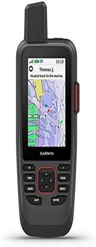
Garmin GPSMAP 86Sci
4.2Editor score
Two-way satellite messaging
BlueChart g3 coastal charts
Compatible chartplotter streaming
A handheld GPS for boating provides a dependable backup when a primary chartplotter is unavailable, power is lost, or a route takes you into unfamiliar water. The most useful models combine accurate positioning, readable marine information, physical controls that can be operated with wet hands, and housings that tolerate spray, rain, and the occasional drop.
We compared the ten products using their stated positioning systems, charting, navigation functions, displays, controls, water resistance, and battery claims. The list covers purpose-built marine handhelds, rugged general-purpose GPS units, a renewed marine model, and an option that adds satellite communication for offshore safety.
Each review identifies the features that distinguish the device and the trade-offs to consider before buying. Rankings reflect the supplied specifications and customer ratings, while current prices and availability can change. Readers should confirm compatibility, subscription requirements, and accessory needs before making a final purchase.
4.2Editor score

4.0Editor score

4.4Editor score
As an Amazon Associate we earn from qualifying purchases.
This side-by-side comparison highlights the chart coverage, positioning systems, physical controls, water resistance, safety functions, and battery life that separate each handheld for time on the water.



The Garmin GPSMAP 79sc is a purpose-built marine handheld with a 4.0 customer rating and a balanced combination of coastal charting, rugged construction, and dependable positioning. It is designed to float and carries IPX6 unit-level water resistance, making it a practical companion for small boats, fishing craft, and coastal voyages where losing the main electronics would be inconvenient.
We may earn a commission when you buy through this link, at no additional cost to you.
Its most valuable boating feature is the preloaded BlueChart g3 coastal chart set. The device also supports GPS, GLONASS, Beidou, Galileo, QZSS, and SBAS, improving the range of positioning options available in different environments. Storage expands to 10,000 waypoints, 250 routes, and 300 fitness activities, while the 3-axis tilt-compensated compass maintains a heading even when the user is stationary.
The high-resolution color display, scratch-resistant fogproof glass, barometric altimeter, and stated battery life of up to 20 hours in GPS mode create a well-rounded feature set. The main limitation is that it does not provide emergency satellite communication. It also cannot stream or receive data from a compatible chartplotter, limiting its usefulness as a fully integrated remote display for a larger Garmin marine system.
The GPSMAP 79sc is the most balanced choice for boaters who want a dedicated marine handheld with coastal charts, a floating body, and broad satellite support. It is especially suitable for coastal navigation, backup navigation, and locations where a conventional general-purpose topo map is less useful. For offshore emergency communication, the GPSMAP 86Sci offers a more specialized alternative.
Preloaded BlueChart g3 coverage gives the GPSMAP 79sc a marine focus that general-purpose handhelds do not provide. It is a more suitable standalone reference for boaters navigating coastal waters than a unit loaded only with TopoActive mapping.
Support for six satellite systems, together with the tilt-compensated electronic compass and barometric altimeter, provides several ways to orient a trip. These features are useful when a vessel is moving slowly, paused, or navigating where a simple line on a basic map would be insufficient.
We may earn a commission when you buy through this link, at no additional cost to you.
The Garmin GPSMAP 79s earns a 4.2 rating and stands out for a worldwide basemap in a floating, water-resistant marine handheld. It is the more versatile member of this list for travelers who divide their time between boating, hiking, and travel, because it is not limited to the coastal chart coverage included with the GPSMAP 79sc.
We may earn a commission when you buy through this link, at no additional cost to you.
Rugged construction, scratch-resistant fogproof glass, and a high-resolution color display make it suitable for demanding outdoor use. The device accepts 10,000 waypoints and 250 routes, supports 300 fitness activities, and tracks GPS, GLONASS, Beidou, Galileo, QZSS, and SBAS. A tilt-compensated 3-axis electronic compass provides a stationary heading, and the barometric altimeter adds another layer of positional information.
The international basemap is the main tradeoff. It helps users understand the wider geographic area, but it is not a replacement for a dedicated BlueChart g3 coastal chart set when detailed marine navigation is the priority. The unit also lacks inReach satellite communication and chartplotter data streaming, keeping it below the GPSMAP 86Sci in integrated marine functionality.
Choose the GPSMAP 79s when you want a rugged handheld that can transition easily from a vessel to shore. It is well suited to international cruising, general route finding, and keeping marine navigation tools close at hand. Boaters who consistently need detailed coastal charts should compare it with the 79sc before deciding.
A worldwide basemap and large activity capacity make the GPSMAP 79s useful beyond the boundaries of a boating day. It can retain hiking routes, travel waypoints, and marine destinations without forcing the owner to carry separate devices for different outdoor activities.
The ability to float provides meaningful protection if the handheld is dropped from a boat. Combined with IPX6 unit-level water resistance and tough glass, it is designed for exposure to spray, rain, and routine handling in wet environments.
We may earn a commission when you buy through this link, at no additional cost to you.
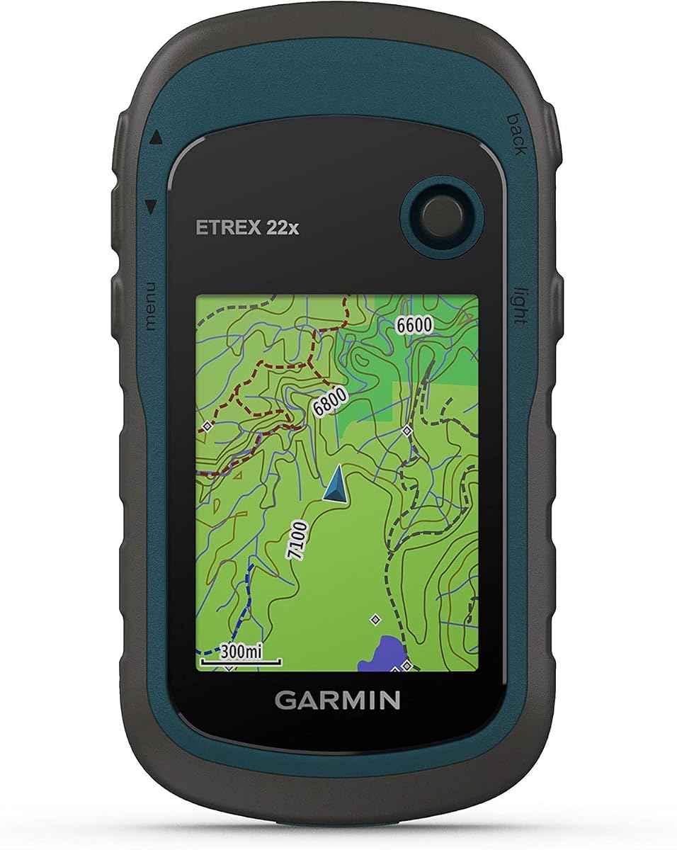
The Garmin eTrex 22x has a 4.3 customer rating and delivers a straightforward, rugged GPS package with a 2.2-inch sunlight-readable color display. It supports GPS and GLONASS, stores map data on 8 GB of internal memory, and includes a microSD card slot for expansion. The stated runtime reaches 25 hours in GPS mode using two AA batteries.
We may earn a commission when you buy through this link, at no additional cost to you.
TopoActive mapping with routable roads and trails makes this model highly capable for shore navigation. The compact display, support for two satellite systems, and field-replaceable battery design are attractive for boaters who also explore islands, trails, and remote coastal areas. The generous battery claim also makes it a useful backup device for longer outings.
Marine functionality is the key limitation. Unlike the purpose-built GPSMAP models, the eTrex 22x does not come with preloaded BlueChart coastal charts or dedicated sailing tools. Its smaller display can also feel constrained when consulting a detailed route, particularly for users wearing gloves or dealing with spray.
The eTrex 22x is best for buyers who want a dependable general-purpose GPS with long battery life and expandable storage. It is a sensible choice for small-boat navigation away from complex waterways and for mixed marine and outdoor use. Those needing detailed coastal charts should favor the 79sc or 86Sci.
The 25-hour GPS mode claim provides useful endurance for day trips and overnight excursions. Using ordinary AA batteries also simplifies field planning because replacement cells are widely available and do not require charging before departure.
Eight gigabytes of internal memory is paired with a microSD card slot, allowing users to retain downloaded maps and expand capacity. This makes the eTrex 22x more flexible for users planning routes across several regions.
We may earn a commission when you buy through this link, at no additional cost to you.
The Garmin GPSMAP 86Sci is the most safety-focused handheld in this guide, carrying a 4.2 rating and combining BlueChart G3 coastal charts with inReach satellite communication. Its floating design, water resistance, button operation, and three-inch sunlight-visible display are all tailored to use around a boat, where touchscreens can be awkward and displays must remain readable in direct sun.
We may earn a commission when you buy through this link, at no additional cost to you.
The device can stream boat data from compatible chartplotters and instruments, consolidating information from a broader marine system. It also functions as a remote for compatible Garmin autopilot and Fusion Marine products after the relevant free Connect IQ apps are downloaded. An adjustable GPS filter helps smooth speed and heading indications across swells, which can improve readability in rough conditions.
The major strength is the optional satellite communication layer. With a subscription, it supports two-way messaging through the Iridium network, location sharing, weather forecasts, and an interactive SOS handled by a 24/7 monitoring center. These capabilities extend safety coverage beyond cellular coverage, although the subscription is required and should be considered before an offshore trip.
The GPSMAP 86Sci is the strongest choice for owners of compatible Garmin equipment who venture beyond reliable cellular service. It is also a premium backup display for larger boats. Buyers who do not need satellite communication or ecosystem integration can find a more focused marine handheld in the GPSMAP 79sc.
Two-way Iridium messaging, location sharing, interactive SOS, and optional weather forecasts can provide a crucial safety layer when a vessel is out of reach of cellular networks. A current satellite subscription is necessary to activate these services.
Streaming data from compatible chartplotters and instruments turns the handheld into more than a standalone navigator. The remote-control function and adjustable GPS filter also make it easier to use information from an integrated onboard system.
We may earn a commission when you buy through this link, at no additional cost to you.
The Garmin GPS 73 has a 4.4 customer rating and offers a focused marine experience through sailing tools, marine alarms, route planning, and a straightforward button interface. Its 2.6-inch display and dedicated backlit buttons are designed for quick recognition in changing conditions, including when the user's hands are cold, wet, or occupied.
We may earn a commission when you buy through this link, at no additional cost to you.
SailAssist includes a virtual starting line, countdown timers, speed history, and tack assist. Marine features include man-overboard support, off-course and anchor-drag alarms, and navigation tools for planning routes. The unit stores up to 1,000 waypoints and 100 tracks, giving it sufficient capacity for many repeat routes and favorite destinations.
Battery life is specified at more than 18 hours with two AA batteries, making the GPS 73 a capable day-trip companion. The trade-off is that it lacks the multi-constellation positioning, high-capacity storage, modern rugged housing, and advanced connectivity found in the premium models. It also has no preloaded BlueChart coastal charts listed in the supplied specifications.
The GPS 73 is an attractive option for sailors and smaller-boat owners who prioritize familiar physical controls and marine-specific assistance over advanced connectivity. It is particularly useful as a simple backup or standalone passage-planning device. Offshore users needing satellite communications should look toward the GPSMAP 86Sci.
The virtual starting line, countdown timer, speed history, and tack assist provide information specifically relevant to sailboat navigation. These functions make the GPS 73 feel purpose-built rather than merely adapted from a general hiking device.
Dedicated backlit buttons and an intuitive interface reduce reliance on precise touchscreen actions. This is a meaningful advantage during a fast-moving approach to a marker or when spray makes a smaller capacitive screen inconvenient to use.
We may earn a commission when you buy through this link, at no additional cost to you.
This renewed Garmin GPSMAP 79sc combines the same marine feature set as the standard model with the highest customer rating in the group, at 4.8. It retains preloaded BlueChart g3 coastal charts, a floating IPX6-rated body, broad satellite support, a 3-axis compass, and a stated battery life of up to 20 hours in GPS mode.
We may earn a commission when you buy through this link, at no additional cost to you.
The renewed version provides the same stated navigation capacity of 10,000 waypoints, 250 routes, and 300 fitness activities. Its high-resolution color display, scratch-resistant fogproof glass, and barometric altimeter also match the original model's specifications. For a boater who understands renewed electronics, those features make the device highly capable as a backup or primary handheld.
Condition is the decisive caveat. A renewed product may show cosmetic wear or have been inspected and tested to a different standard than a factory-new unit, although the supplied information does not specify the exact condition of any individual device. It also lacks the satellite communication and chartplotter integration available on the GPSMAP 86Sci.
The renewed GPSMAP 79sc is well suited to cost-conscious buyers who prioritize established marine features over factory-new presentation. Review the listing's condition details carefully and confirm the included accessories before ordering. If condition uncertainty is unacceptable, the standard 79sc is the more predictable choice.
The renewed listing retains the core capabilities that make the GPSMAP 79sc useful on the water. Coastal charts, multiple satellite systems, a floating housing, and substantial waypoint and route storage remain the priorities over cosmetic perfection.
Condition details, included accessories, battery condition, and the seller's warranty terms should be reviewed before purchase. Renewed status can reduce risk for informed buyers, but it does not make every unit identical in appearance or age.
We may earn a commission when you buy through this link, at no additional cost to you.
The Garmin GPSMAP 65 combines a 4.5 rating with advanced positioning features, including expanded global navigation satellite system support and multi-band technology. The multi-band system is designed to improve accuracy in challenging locations such as steep terrain, urban canyons, and forests with dense tree cover, where satellite signals can be obstructed or reflected.
We may earn a commission when you buy through this link, at no additional cost to you.
Its 2.6-inch sunlight-readable color display is larger than the screens found on many basic handhelds. Button operation offers dependable tactile control, including in wet conditions or while wearing gloves. Routable TopoActive mapping and a U.S.-only federal public land map make it especially useful for exploring routes ashore.
The unit is not explicitly a marine model. The supplied specifications do not list preloaded coastal charts, sailing assistance, man-overboard functions, or an inflatable floating housing. It also lacks satellite communication, so it cannot provide the same remote safety coverage as the GPSMAP 86Sci.
The GPSMAP 65 is a strong choice for boaters who spend substantial time on land around coastal trips and want advanced positioning performance. It also works as a capable general-purpose handheld. If detailed marine charts and a floating body are essential, the 79sc or 86sci is the better fit.
Multi-band technology can improve location accuracy in places where conventional single-band reception is challenged. The benefit is most relevant around steep terrain, dense woodland, and built-up areas rather than on wide-open water.
The 2.6-inch sunlight-readable screen provides more room for route detail than a compact 2.2-inch model. Tactile buttons preserve a straightforward operating method when wet conditions make touch interaction less reliable.
We may earn a commission when you buy through this link, at no additional cost to you.
The Garmin eTrex 32x is a rugged general-purpose GPS with a 4.2 rating, a 2.2-inch sunlight-readable color display, and a useful set of orientation sensors. Compared with the eTrex 22x, it adds a 3-axis compass and barometric altimeter, giving users more ways to establish direction and elevation.
We may earn a commission when you buy through this link, at no additional cost to you.
TopoActive mapping includes routable roads and trails, while support for GPS and GLONASS improves tracking in challenging environments. The handheld provides 8 GB of internal storage for map downloads and accepts microSD cards. Two AA batteries power it for up to 25 hours in GPS mode, according to the supplied specifications.
Its limitations mirror those of most hiking-oriented units. The listed mapping is topographic rather than a dedicated marine chart set, and the product is not presented as a floating waterproof marine handheld. The smaller display also offers less space to inspect dense routes or marine markings than the three-inch GPSMAP 86Sci.
For boaters who split time between the water and land, the eTrex 32x offers a helpful combination of compass, altimeter, expandable storage, and long battery life. It is particularly attractive for coastal hiking and campsite navigation. Buyers whose primary need is boating charts should choose a dedicated marine model instead.
The three-axis compass and barometric altimeter distinguish the 32x from simpler entry-level handhelds. They provide useful heading and elevation information for shore trips, coastal trails, and routes where landmarks are difficult to identify.
The stated 25-hour runtime reduces the chance of a dead navigator during a long day outdoors. Common AA batteries can be replaced without a charger, and expanded card storage leaves room for additional regional map downloads.
We may earn a commission when you buy through this link, at no additional cost to you.
The Garmin eTrex SE stands out for endurance, with a stated battery life of up to 168 hours in standard mode and up to 1,800 hours in expedition mode. It also has a 2.2-inch high-resolution display that is designed to remain readable in bright sunlight and a water-resistant housing rated to IPX7.
We may earn a commission when you buy through this link, at no additional cost to you.
Multi-GNSS support includes GPS, GLONASS, Galileo, BeiDou, and QZSS, allowing the receiver to use multiple navigation systems. A digital compass supplies a heading even when the user is stationary. When paired with a compatible smartphone through the Garmin Explore app, it supports wireless software updates, trip planning, Active Weather, smart notifications, and additional mapping.
The eTrex SE is primarily an outdoor and expedition navigator rather than a dedicated marine handheld. The supplied specifications do not mention preloaded BlueChart charts, sailing tools, chartplotter integration, or a floating body. IPX7 water resistance is valuable, but it should not be confused with the specialized features of a marine GPS.
It is a compelling choice for boaters undertaking extended coastal expeditions or spending time ashore in wet environments. The extraordinary expedition battery claim can reduce charging concerns, although users must provide their own AA batteries. For routine navigation with detailed coastal charts, the GPSMAP 79sc remains more purpose-focused.
The standard and expedition battery claims make the eTrex SE useful for remote journeys where charging opportunities are limited. Expedition mode extends endurance considerably, although it should be understood as a power-saving operating mode rather than a guarantee for every feature setting.
Garmin Explore compatibility adds trip planning, weather information, notifications, updates, and extra mapping through a compatible phone. The connection expands the handheld's usefulness without turning it into a phone-dependent device for basic positioning.
We may earn a commission when you buy through this link, at no additional cost to you.
The Garmin GPS 76 is a traditional handheld navigator with a 4.6 customer rating, a WAAS-enabled GPS receiver, and a straightforward set of trip computer functions. Its receiver can continuously track and use up to 12 satellites, providing the fundamental positioning foundation expected from a dedicated GPS unit.
We may earn a commission when you buy through this link, at no additional cost to you.
The included trip computer reports current and average speed, elapsed time, and trip distance. Two AA alkaline batteries deliver up to 16 hours of use, making the unit simple to keep ready for occasional trips. It is a less complicated alternative for owners who want basic position fixing and trip information without a larger marine display or extensive storage.
Storage is the largest limitation. The device has only 1 MB of memory for downloadable data from optional Garmin MapSource CD-ROMs, a severe restriction by modern navigation standards. It also lacks the multi-constellation support, color display, built-in compass, barometric altimeter, coastal charts, and satellite communication found in the newer products in the guide.
The GPS 76 makes sense as a simple backup or occasional-use navigator for owners who prioritize familiar controls, a strong rating, and uncomplicated operation. It is not the most capable marine option, so anyone expecting detailed coastal charts or integration with modern electronics should choose a GPSMAP 79sc or 86Sci instead.
WAAS-enabled reception and support for as many as 12 satellites provide a dependable basis for basic position tracking. The specification is especially understandable for users who prefer a traditional receiver without a large collection of connected features.
Current speed, average speed, timer, and trip distance cover the most common needs for a day on the water. These functions make the GPS 76 a functional backup for short trips, although storage limits restrict more advanced route work.
We may earn a commission when you buy through this link, at no additional cost to you.
The right boating handheld depends on where you travel, how you use the device, which electronics are already aboard, and how much safety redundancy you want beyond the primary chartplotter. Chart detail, water resistance, controls, battery life, and satellite support should be evaluated together rather than in isolation.
Choose a handheld with marine charting whenever the device is expected to serve as a real navigation backup.
Prioritize a floating design and clearly stated water-resistance rating for regular use on open water.
Choose broader satellite support when you regularly navigate near terrain, forests, or urban obstructions.
Balance screen size against control simplicity, prioritizing sunlight visibility and buttons you can operate confidently.
Match stated runtime to trip length, and carry replacement batteries for any journey away from reliable charging.
Check for dedicated alarms, man-overboard support, and sailing tools when they may affect emergency decisions.
Choose satellite communication when traveling beyond reliable cellular coverage, and verify subscription and device compatibility.
Choose sufficient storage and a practical update method for the number of routes and regions you expect to use.
Before leaving shore, enter the trip plan, confirm the device is receiving a position, verify the intended route, and make sure the battery is charged or fitted with fresh batteries. Learn the power, zoom, mark, back, and route functions before reaching the water. Download any required charts or mapping in advance, and confirm that a marine chart covers every area on the itinerary.
Keep the handheld accessible but secured against loss. Use a lanyard or suitable retention system, protect the screen from excessive glare, and dry the unit after handling it in salt water. After a fall into the water, retrieve it, rinse it with fresh water, remove excess moisture from the ports, and allow it to dry before charging or storing it. Follow the manufacturer's guidance for battery care and replacement.
Treat the handheld as a backup and cross-check critical information against current charts, familiar landmarks, and the boat's primary electronics. Satellite messaging services require an active subscription, while connected functions require compatible devices and apps. Review updates, subscriptions, and stored routes before each major trip, and keep a separate navigation plan aboard in case the electronic unit becomes unavailable.
A handheld GPS is a valuable backup because a chartplotter can lose power, fail, suffer water damage, or become difficult to operate in an emergency. A floating marine model can also be carried onto a dinghy, used during a swim, or deployed from a shore while keeping the primary electronics operating. It should complement, not replace, properly maintained onboard equipment and established passage-planning practices.
The Garmin GPSMAP 86Sci is the most capable offshore-focused model in this list because it combines BlueChart G3 coastal charts with inReach satellite communication. With an active subscription, it can provide two-way messaging, weather forecasts, location sharing, and interactive SOS service beyond cellular coverage. Boaters should also carry conventional safety equipment and maintain a separate emergency plan.
A general-purpose handheld can provide positioning and basic route guidance, but it may not include coastal charts, sailing functions, marine alarms, or a floating housing. Devices such as the eTrex 22x and 32x are strongest for mixed boating and outdoor use. Those who rely on the handheld for primary passage navigation should favor a purpose-built marine model with appropriate chart coverage.
A floating handheld is designed to remain on the surface after falling overboard, making it easier to locate and recover. This is more useful than a non-floating device that immediately sinks. Water resistance and floating ability are separate qualities, so buyers should examine both when choosing a unit for regular use around a boat.
Core positioning and navigation features are designed to function on the handheld itself. The eTrex SE gains trip planning, weather, notifications, updates, and additional mapping when paired with a compatible smartphone through Garmin Explore. The GPSMAP 86Sci's satellite communication also requires a service subscription, but its basic navigation functions do not depend on a paired phone.
A larger screen can show more of a route, surrounding water, and chart detail at once, which may help on a complex passage. The three-inch GPSMAP 86Sci offers the largest stated display in this group. However, a smaller unit with tactile buttons can be easier to handle in spray or with gloves, so display size should be balanced against control accessibility and portability.
IPX6 indicates resistance to powerful water jets under specified test conditions, while IPX7 indicates protection against temporary immersion in water under defined test conditions. Neither rating should be interpreted as permission to submerge a device beyond its stated limits. Floating capability is also a separate feature and should be considered when evaluating overboard recovery.
Update the handheld's software and mapping through the appropriate Garmin method, then confirm that the charts cover the entire route. The eTrex SE offers direct wireless updates and trip planning through Garmin Explore, while other models may require a computer connection or compatible transfer procedure. Download the required data before departure and carry a separate chart or route plan as a backup.
The Garmin GPSMAP 79sc is the most balanced standalone marine handheld, combining floating construction, BlueChart g3 coastal charts, broad satellite support, and useful navigation storage. The GPSMAP 86Sci is the feature-rich premium choice for compatible Garmin systems and offshore safety, while the GPS 73 offers accessible marine navigation, sailing tools, and uncomplicated button operation for simpler needs.
Prioritize the features that match your actual route. Coastal boaters should begin with marine charting and a floating, water-resistant body. Offshore travelers should seriously consider satellite communication and the associated subscription, while users who divide their time between water and land may prefer a general-purpose handheld with a compass, expandable storage, and long battery life.
Before ordering, confirm chart coverage, battery requirements, subscription terms, accessory compatibility, and the device's physical controls. Current prices change, so compare final listings and seller details at the time of purchase, and treat a handheld as one layer of a broader boating safety plan rather than a substitute for sound seamanship.